
Southwest - Sant'Antioco / San Pietro
Sulcis Iglesiente
The Sulcis-Iglesiente region is situated in the south west of Sardinia.
This region, one of the most ancient parts of Europe, reveals, with the conformation of its rocks and their bizarre formations, the effects left on it by four geological eras. The geological phases of this region cover eras from the Palaeozoic to the Pleistocene.
This area in 1998 has been officially declared First Mining Park in the world for its geological, historical and environmental importance. This Park represents the first example of Geosites/Geoparks established during The General Conference of Unesco.
The geo mining park covers an area of 2.445 sq km and for the rich deposits of lead, zinc, copper, tin, silver and iron it has been acknowledged as one of the most important metal districts of Western Europe.
These mines where already exploited in the Bronze Age by the Nuraghic people who had metalworking skills and there is also evidence of Phoenician and Roman mines.
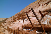
During the boom of the 19th century industrialisation, the mining activities grew considerably and soon became one of the main resources for the economic development of the island. On the land of coal and metals the cranes, pylons, big slagheaps, cableways, shafts, excavator and other structures transformed the wild landscape. Today all that remains of those flourishing times is a rich heritage of mining archaeology as part of the Sardinian culture and past life.
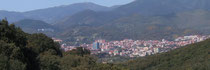
The systematic intensive exploitation of Sulcis coal seams started in 1939, just around the time of foundation of the city of Carbonia by Mussolini. Before then the local people used to be simple shepherds and peasants who lived in poor villages often surrounded by marshy malaric fields, or in the stone sheep-pens called “furriadroxius”. Carbonia grew up and spread over a wide area all of a sudden, with its strict city plan characterized by wide straight avenues, regular wide squares and elegant public buildings. Miners and workers from all over Italy moved to this town where the population soon reached 50.000 inhabitants. Carbonia was for quite a while one of the most progressive and dynamic cities in Sardinia.

The area around Carbonia is also rich in archaeology. The archaeological site of Monte Sirai represents one of the only Phoenician-Punic inland settlements. The site comprises the fortified city with stunning views of Sant’Antioco and San Pietro islands, a necropolis with three different types of burial tombs and the Tophet the funerary infant area.
There are also nuraghi like the site of Pani loriga and the village of Serucci.
The Iglesiente was the mining heart of Sardinia with the structures and houses of Monteponi.
The Count Ugolino della Gherardesca from Pisa founded the city of Villa Ecclesiarum in the 13th century, city that grew in to an important mining area also under the Spanish who changed the name in to Iglesias. The historical centre is still very pretty and has preserved The Romanesque Cathedral of Santa Chiara, the XIVth-cent. Church of San Francesco and other interesting buildings.

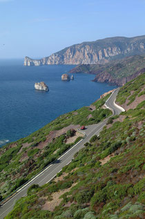
Leaving Iglesias we travel on the formidable coast road, which winds its way past Nebida and Masua, discovering striking sea-views at every bend of the road. Cliff and rocks are just stunning with the incredible rock formation of Pan di Zucchero (sugar loaf) that soars into the air as if it was the extreme rampart of the island.

Splendid beaches can be seen in Buggerru like Cala Domestica. In the territory of Fluminimaggiore we find the nice resort of Portixeddu and in the countryside in a green valley, lies the Temple of Antas an ancient site of the nuragic times which was later enlarged and embellished by the Carthaginians and the Romans.

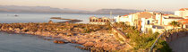
The island of Sant’Antioco.
Founded by the Phoenicians around the VIIIth cent, B.C. under the name Solki, Sant’Antioco is the main city on the island of the same name. The town offers many places of interest and a nice lively centre with shaded avenues of trees and delightful restaurants. Just above the town that climbs away from the sea we find the Basilica of Sant’Antioco, an example of early Christian church dating from the 6th cent. A.D. characterized by central dome with a Greek plan.

Underground the church a series of catacombs are well preserved and some of them still reveal traces of frescoes. The African saint and martyr Sant'Antioco is buried in the catacombs, place used as a refuge during the Roman persecutions to Christians.
Not far from this church there is an Archaeological Museum containing various objects and earthenware found in the area. The Ethnographic Museum houses ancient traditional tools, spindles and looms and wine making equipment.

On the town hill slope there is a large Punic and roman necropolis, and the Tophet an infant burial place used by the Carthaginians, with urns and pottery containing the baby’s ashes. A little Castle dating from the Savoy period built to protect the city from the pirates Barbaresque raids dominates the town. Sant’Antioco beaches and coast are very beautiful.
Calasetta is the second largest village on the island of Sant’Antioco. It is a very pretty and picturesque little town founded by a group of Ligurian fishermen who arrived from Tabarka in Tunisia in 1769.

The coast around this town is very nice with stunning cliffs, beaches and coves.
Nice restaurants, narrow little streets and the port area in summertime at night get crowded with people who enjoy a stroll after dinner.